Inba District
Appearance
This article needs additional citations for verification. (June 2023) |


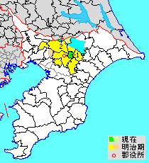
Blue and light green: Shimo-Habu-gun=Lower Habu District
Green: present-day remainder of Inba
Red circle: seat of the modern (1878–1926) district government
Orange: ceded from Inba to Chiba District (Yachiyo Town) in 1954
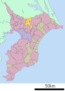
Inba District (印旛郡, Inba-gun) is a district located in Chiba Prefecture, Japan.
As of 2011, the district has an estimated population of 43,480 and a density of 845 persons per km2. The total area is 51.48 km2.[1]
There are two towns within the district.
District timeline
[edit]- January 1, 1957 - Parts of Yotsukaidō merged into the city of Sakura.
- September 1, 1964 - The village of Shiroi gained town status.
- April 1, 1981 - The town of Yotsukaidō gained city status.
- April 1, 1985 - The village of Tomisato gained town status.
- April 1, 1992 - The town of Yachimata gained city status.
- April 1, 1996 - The town of Inzai gained city status.
- April 1, 2001 - The town of Shiroi gained city status.
- April 1, 2002 - The town of Tomisato gained city status.
- March 23, 2010 - The villages of Inba and Motono merged into the city of Inzai.
35°49′26″N 140°15′22″E / 35.824°N 140.256°E
References
[edit]- ^ "Inba (District (-gun), Chiba, Japan) - Population Statistics, Charts, Map and Location". www.citypopulation.de. Retrieved June 13, 2023.
