Place des Vosges
This article has multiple issues. Please help improve it or discuss these issues on the talk page. (Learn how and when to remove these messages)
|
 Aerial view of the Place des Vosges | |
| Length | 140 m (460 ft) |
|---|---|
| Width | 140 m (460 ft) |
| Arrondissement | 3rd, 4th |
| Quarter | Archives. Arsenal. |
| Coordinates | 48°51′20″N 2°21′56″E / 48.85556°N 2.36556°E |
| From | rue de Birague, 11 bis |
| To | rue de Béarn, 1 |
| Construction | |
| Completion | July 1605 |
The Place des Vosges (French pronunciation: [plas de voʒ]), originally the Place Royale, is the oldest planned square in Paris, France. It is located in the Marais district, and it straddles the dividing-line between the 3rd and 4th arrondissements of Paris. It is the oldest square in Paris, just before the Place Dauphine. It is an enclosed square, accessible via a main street on one of its four sides and two streets running beneath pavilions. It was a fashionable and expensive square to live in during the 17th and 18th centuries, and one of the main reasons for the chic nature of Le Marais among the Parisian nobility. Along with the Place des Victoires, Place Dauphine, Place Vendôme and Place de la Concorde, it is one of the five royal squares in Paris.
History
[edit]Originally known as the Place Royale, the Place des Vosges was built by Henri IV from 1605 to 1612. A true square (140 m × 140 m), it embodied one of the first European programs of royal city planning (Plaza Mayor in Madrid, begun in 1590, precedes it). It was built on the site of the Hôtel des Tournelles and its gardens, which were demolished by Catherine de' Medici.

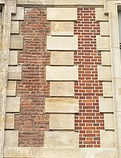
The Place Royale was inaugurated in 1612 with a grand carrousel to celebrate the engagement of Louis XIII and Anne of Austria, and became a prototype of the residential squares of European cities that were to come. What was new about the Place Royale, was that the house-fronts were all built to the same design, probably by Jean Baptiste Androuet du Cerceau,[1] of red brick with strips of stone quoins over vaulted arcades that stand on square pillars. The steeply-pitched blue slate roofs are pierced with discreet small-paned dormers above the pedimented dormers that stand upon the cornices. Only the north range was built with the vaulted ceilings that the "galleries" were meant to have.
There are two pavilions that rise higher than the unified roofline of the square on the north and south faces and offer access to the square through triple arches. Though they are designated the Pavilion of the King and of the Queen, no royal has ever lived in the aristocratic square, except for Anne of Austria who lived in the Pavilion de la Reine for a short while. The Place Royale inspired subsequent developments of Paris that created a suitable urban background for the French aristocracy and nobility.
The square was often the place for the nobility to chat, and served as a meeting place for them. This was so until the French Revolution.
Before the square was completed, Henri IV ordered the Place Dauphine to be laid out. Within a mere five-year period, the king oversaw an unmatched building scheme for the ravaged medieval city: additions to the Louvre Palace, the Pont Neuf, and the Hôpital Saint Louis as well as the two royal squares.
Cardinal Richelieu had an equestrian bronze of Louis XIII erected in the centre. In the late 18th century, while most of the nobility moved to the Faubourg Saint-Germain district, the square managed to keep some of its aristocratic owners until the Revolution. It was briefly renamed "Place de la Fabrication-des-Armes" (the place were weapons are produced) then in 1800, it was formally renamed to Place des Vosges in honor of the département of Vosges which was the first to pay taxes supporting a campaign of the Revolutionary army. From 1814 until 1830, and from 1852 until 1870, the name was changed back to the original by the Restoration monarchs. In 1830 the name was briefly switched to being "Place de la République". Finally in 1870 the revolutionary name was restored.
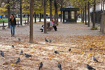
Today the square is planted with a bosquet of mature lindens set in grass and gravel, surrounded by clipped lindens.
 |
|

Residents of the Place des Vosges
- No. 1bis: Madame de Sevigné was born here
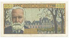
- No. 6 (Maison de Victor Hugo): Victor Hugo's home from 1832 to 1848, in what was then the Hôtel de Rohan, now a museum devoted to his memory, managed by the City of Paris
- No. 7: Sully, Henri IV's great minister
- No. 8: poet Théophile Gautier and writer Alphonse Daudet
- No. 9 (Hôtel de Chaulnes): seat of l'Académie d'Architecture, currently also tenanted by Galerie Historisimus
- No. 11: courtesan Marion Delorme from 1639 to 1648
- No. 12: natural philosopher and mathematician Émilie du Châtelet[2]
- No. 14 (Hôtel de la Rivière): rabbi David Feuerwerker, Antoinette Feuerwerker and Atara Marmor
- No. 15: Marguerite Louise d'Orléans, wife of Cosimo III de' Medici Grand Duke of Tuscany. Its ceilings painted by Lebrun are reinstalled in the Musée Carnavalet.
- No. 17: bishop and theologian Bossuet
- No. 20: Prince Obolensky Arnaud Henry Salas-Perez
- No. 21: Cardinal Richelieu from 1615 to 1627
- No. 23: Post-Impressionist painter Georges Dufrénoy
- No. 28 (Pavillon de la Reine): Chabot-Rohan family
See also
[edit]Notes
[edit]- ^ . Other architects, like Louis Métezeau, were responsible for the constructions erected behind these regular façades
- ^ Zinsser, Judith (2006). Daring Genius of the Enlightenment. Penguin. p. 21. ISBN 9780143112686.
References
[edit]- Hilary Ballon, The Paris of Henry IV: Architecture and Urbanism, 1994 ISBN 0-262-52197-0
- DeJean, Joan. "'Light of the city of light' The Place des Vosges" in her How Paris Became Paris: The Invention of the Modern City NY:Bloomsbury, 2014. ISBN 978-1-60819-591-6. chapter 2, pp. 45–61.
External links
[edit]- Place des Vosges, Discovering the Historic Place des Vosges: Parisian Charm and Cultural Significance
- "Paris Pages; Monuments; Place des Vosges". Archived from the original on 10 March 2010.
- Satellite image from Google Maps
- [1] Place des Vosges audio tour
- dans le parc


